63 Geography
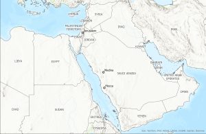
The Arabian Peninsula is the largest peninsula in the world. As you can see in the map below, Arabia lies east of the African continent, separated by the Red Sea. On the eastern side of the peninsula is the Indian Ocean. With its central location, Arabia is well positioned for international trade through the sea and over land. Overland trading routes depended on the camel, a unique quadruped that could transport goods and endure the harsh desert climate. However, large areas on the eastern and northern side of the peninsula are too arid to have been penetrated by trade routes. Much of the overland trade was concentrated along the western side of the peninsula. These routes developed east of tall mountains that range along the Red Sea. They connect cities of the Arabian Peninsula that are important in the history of Islam.
Sea routes in the Indian Ocean connected the eastern and southern coasts of the Arabian Peninsula to India and China. On the west side, sea routes traveled the Red Sea north to trade with Mediterranean cultures. Arabia traded precious commodities of the desert such as frankincense and myrrh that were used in rituals throughout the ancient world. Although the Arabian Peninsula is sometimes called the “Island of the Arabs,” it was not isolated from other cultures. Rather, its position meant that Arabs were able to trade in the East as well as the West.